


la tamarisienne

Steph0726
User

Length
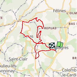
17.5 km

Max alt
654 m

Uphill gradient
502 m
Km-Effort
24 km

Min alt
391 m

Downhill gradient
507 m
Boucle
Yes
Creation date :
2019-10-27 08:43:07.086
Updated on :
2019-10-27 13:38:56.777
4h53
Difficulty : Easy

FREE GPS app for hiking
 SityTrail
IGN / Geographical institutes
SityTrail Plus
The world is yours!
About
Trail Walking of 17.5 km to be discovered at Auvergne-Rhône-Alpes, Ardèche, Peaugres. This trail is proposed by Steph0726.
Description
rando APEL
Positioning
Country:
France
Region :
Auvergne-Rhône-Alpes
Department/Province :
Ardèche
Municipality :
Peaugres
Location:
Unknown
Start:(Dec)
Start:(UTM)
635179 ; 5015963 (31T) N.
Comments