


Tourves Valbelle St Probace

chrifor
User
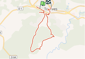

Length
9 km

Max alt
513 m

Uphill gradient
259 m
Km-Effort
12.6 km

Min alt
285 m

Downhill gradient
288 m
Boucle
No
Creation date :
2019-10-27 09:44:33.122
Updated on :
2020-05-27 11:03:39.554
3h47
Difficulty : Very easy

FREE GPS app for hiking
 SityTrail
IGN / Geographical institutes
SityTrail Plus
The world is yours!
About
Trail Walking of 9 km to be discovered at Provence-Alpes-Côte d'Azur, Var, Tourves. This trail is proposed by chrifor.
Photos


Positioning
Country:
France
Region :
Provence-Alpes-Côte d'Azur
Department/Province :
Var
Municipality :
Tourves
Location:
Unknown
Start:(Dec)
Start:(UTM)
736129 ; 4810243 (31T) N.
Comments