


montricoux1

ra2000
User
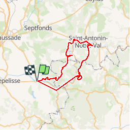

Length
50 km

Max alt
383 m

Uphill gradient
1665 m
Km-Effort
72 km

Min alt
97 m

Downhill gradient
1665 m
Boucle
Yes
Creation date :
2019-10-27 08:46:58.684
Updated on :
2019-10-27 17:47:40.448
7h31
Difficulty : Very difficult

FREE GPS app for hiking
 SityTrail
IGN / Geographical institutes
SityTrail Plus
The world is yours!
About
Trail Mountain bike of 50 km to be discovered at Occitania, Tarn-et-Garonne, Montricoux. This trail is proposed by ra2000.
Description
petite variante par rapport à montricoux
Positioning
Country:
France
Region :
Occitania
Department/Province :
Tarn-et-Garonne
Municipality :
Montricoux
Location:
Unknown
Start:(Dec)
Start:(UTM)
389239 ; 4881209 (31T) N.
Comments