


HiHTBMdo4xw

papajp
User
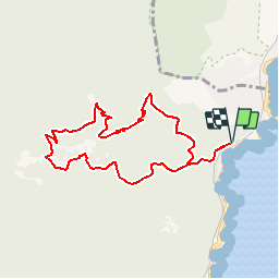

Length
8.9 km

Max alt
489 m

Uphill gradient
473 m
Km-Effort
15.2 km

Min alt
28 m

Downhill gradient
473 m
Boucle
Yes
Creation date :
2019-10-28 07:04:32.0
Updated on :
2019-10-29 16:27:18.794
--
Difficulty : Easy

FREE GPS app for hiking
 SityTrail
IGN / Geographical institutes
SityTrail Plus
The world is yours!
About
Trail On foot of 8.9 km to be discovered at Provence-Alpes-Côte d'Azur, Var, Saint-Raphaël. This trail is proposed by papajp.
Positioning
Country:
France
Region :
Provence-Alpes-Côte d'Azur
Department/Province :
Var
Municipality :
Saint-Raphaël
Location:
Unknown
Start:(Dec)
Start:(UTM)
332143 ; 4815648 (32T) N.
Comments