


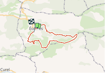
EOURRES Pied du Mulet . Col de Verdun. Col Saint Pierre . o

RobinMicheline
User GUIDE

Length
14 km

Max alt
1608 m

Uphill gradient
866 m
Km-Effort
26 km

Min alt
952 m

Downhill gradient
885 m
Boucle
No
Creation date :
2019-10-17 07:03:39.464
Updated on :
2020-01-07 17:42:49.338
6h43
Difficulty : Medium

FREE GPS app for hiking
 SityTrail
IGN / Geographical institutes
SityTrail Plus
The world is yours!
About
Trail Walking of 14 km to be discovered at Provence-Alpes-Côte d'Azur, Hautes-Alpes, Éourres. This trail is proposed by RobinMicheline.
Description
super brouillard jolis sentiers bien ombragés
Positioning
Country:
France
Region :
Provence-Alpes-Côte d'Azur
Department/Province :
Hautes-Alpes
Municipality :
Éourres
Location:
Unknown
Start:(Dec)
Start:(UTM)
715454 ; 4898687 (31T) N.
Comments