


cupelin combloux cupelin

lionel4806
User
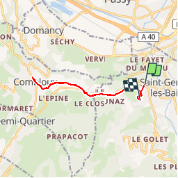

Length
11.3 km

Max alt
1000 m

Uphill gradient
351 m
Km-Effort
15.7 km

Min alt
891 m

Downhill gradient
252 m
Boucle
No
Creation date :
2019-10-29 12:38:47.172
Updated on :
2019-10-29 16:28:27.66
3h40
Difficulty : Very easy

FREE GPS app for hiking
 SityTrail
IGN / Geographical institutes
SityTrail Plus
The world is yours!
About
Trail Walking of 11.3 km to be discovered at Auvergne-Rhône-Alpes, Upper Savoy, Saint-Gervais-les-Bains. This trail is proposed by lionel4806.
Positioning
Country:
France
Region :
Auvergne-Rhône-Alpes
Department/Province :
Upper Savoy
Municipality :
Saint-Gervais-les-Bains
Location:
Unknown
Start:(Dec)
Start:(UTM)
321510 ; 5084801 (32T) N.
Comments