


Rivière Langevin

XavierFaidix
User
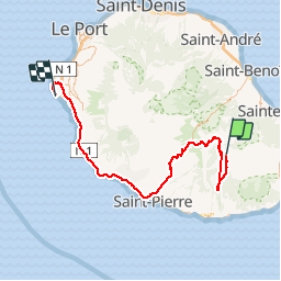

Length
116 km

Max alt
2371 m

Uphill gradient
3402 m
Km-Effort
169 km

Min alt
6 m

Downhill gradient
5671 m
Boucle
No
Creation date :
2019-10-29 04:54:21.765
Updated on :
2019-10-29 16:36:14.289
5h00
Difficulty : Difficult

FREE GPS app for hiking
 SityTrail
IGN / Geographical institutes
SityTrail Plus
The world is yours!
About
Trail Walking of 116 km to be discovered at Réunion, Unknown, Sainte-Rose. This trail is proposed by XavierFaidix.
Positioning
Country:
France
Region :
Réunion
Department/Province :
Unknown
Municipality :
Sainte-Rose
Location:
Unknown
Start:(Dec)
Start:(UTM)
361141 ; 7651742 (40K) S.
Comments