


Montgueux-11-4

DomifaC
User
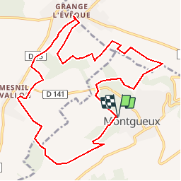

Length
11.4 km

Max alt
272 m

Uphill gradient
248 m
Km-Effort
14.7 km

Min alt
150 m

Downhill gradient
247 m
Boucle
Yes
Creation date :
2019-04-29 12:35:42.707
Updated on :
2019-10-29 22:28:53.252
2h43
Difficulty : Medium

FREE GPS app for hiking
 SityTrail
IGN / Geographical institutes
SityTrail Plus
The world is yours!
About
Trail Nordic walking of 11.4 km to be discovered at Grand Est, Aube, Montgueux. This trail is proposed by DomifaC.
Description
Facile
Positioning
Country:
France
Region :
Grand Est
Department/Province :
Aube
Municipality :
Montgueux
Location:
Unknown
Start:(Dec)
Start:(UTM)
570758 ; 5350738 (31U) N.
Comments