


les mouyon

ymobernard
User
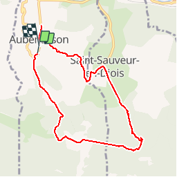

Length
8.5 km

Max alt
693 m

Uphill gradient
435 m
Km-Effort
14.3 km

Min alt
297 m

Downhill gradient
428 m
Boucle
Yes
Creation date :
2019-10-16 11:55:58.635
Updated on :
2019-10-30 09:29:48.828
3h10
Difficulty : Medium

FREE GPS app for hiking
 SityTrail
IGN / Geographical institutes
SityTrail Plus
The world is yours!
About
Trail Walking of 8.5 km to be discovered at Auvergne-Rhône-Alpes, Drôme, Aubenasson. This trail is proposed by ymobernard.
Positioning
Country:
France
Region :
Auvergne-Rhône-Alpes
Department/Province :
Drôme
Municipality :
Aubenasson
Location:
Unknown
Start:(Dec)
Start:(UTM)
669585 ; 4950001 (31T) N.
Comments