


Soum d' Ostès Repérage G2 LPC

mitch1952
User
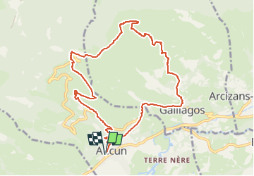

Length
11 km

Max alt
1453 m

Uphill gradient
703 m
Km-Effort
20 km

Min alt
872 m

Downhill gradient
704 m
Boucle
Yes
Creation date :
2019-10-30 14:46:33.961
Updated on :
2022-06-08 10:48:08.674
4h38
Difficulty : Very difficult

FREE GPS app for hiking
 SityTrail
IGN / Geographical institutes
SityTrail Plus
The world is yours!
About
Trail Walking of 11 km to be discovered at Occitania, Hautespyrenees, Aucun. This trail is proposed by mitch1952.
Positioning
Country:
France
Region :
Occitania
Department/Province :
Hautespyrenees
Municipality :
Aucun
Location:
Unknown
Start:(Dec)
Start:(UTM)
728723 ; 4761633 (30T) N.
Comments