


labrune
User
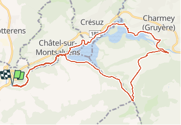

Length
12.4 km

Max alt
982 m

Uphill gradient
446 m
Km-Effort
18.4 km

Min alt
712 m

Downhill gradient
447 m
Boucle
Yes
Creation date :
2014-12-11 00:00:00.0
Updated on :
2014-12-11 00:00:00.0
--
Difficulty : Unknown

FREE GPS app for hiking
 SityTrail
IGN / Geographical institutes
SityTrail Plus
The world is yours!
About
Trail Walking of 12.4 km to be discovered at Fribourg, Gruyère District, Broc. This trail is proposed by labrune.
Description
2.50 h. marche réelle (GPS)
Positioning
Country:
Switzerland
Region :
Fribourg
Department/Province :
Gruyère District
Municipality :
Broc
Location:
Unknown
Start:(Dec)
Start:(UTM)
355538 ; 5162966 (32T) N.
Comments