


meudon 19 10 2019

adubarry
User
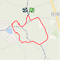

Length
3.4 km

Max alt
186 m

Uphill gradient
64 m
Km-Effort
4.3 km

Min alt
125 m

Downhill gradient
63 m
Boucle
Yes
Creation date :
2019-10-19 13:08:37.942
Updated on :
2019-10-30 21:51:37.504
1h37
Difficulty : Very easy

FREE GPS app for hiking
 SityTrail
IGN / Geographical institutes
SityTrail Plus
The world is yours!
About
Trail Walking of 3.4 km to be discovered at Ile-de-France, Hauts-de-Seine, Meudon. This trail is proposed by adubarry.
Positioning
Country:
France
Region :
Ile-de-France
Department/Province :
Hauts-de-Seine
Municipality :
Meudon
Location:
Unknown
Start:(Dec)
Start:(UTM)
441641 ; 5405660 (31U) N.
Comments