


givry 2

desbois
User
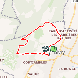

Length
6.3 km

Max alt
382 m

Uphill gradient
181 m
Km-Effort
8.7 km

Min alt
226 m

Downhill gradient
182 m
Boucle
Yes
Creation date :
2019-10-31 14:35:27.57
Updated on :
2019-10-31 14:38:03.142
--
Difficulty : Very easy

FREE GPS app for hiking
 SityTrail
IGN / Geographical institutes
SityTrail Plus
The world is yours!
About
Trail On foot of 6.3 km to be discovered at Bourgogne-Franche-Comté, Saône-et-Loire, Givry. This trail is proposed by desbois.
Description
gr 4
Positioning
Country:
France
Region :
Bourgogne-Franche-Comté
Department/Province :
Saône-et-Loire
Municipality :
Givry
Location:
Unknown
Start:(Dec)
Start:(UTM)
632650 ; 5182368 (31T) N.
Comments