


20180719140133-WA2K2

daniel_2w
User

Length
32 km

Max alt
409 m

Uphill gradient
792 m
Km-Effort
43 km

Min alt
206 m

Downhill gradient
791 m
Boucle
Yes
Creation date :
2019-10-31 20:12:55.171
Updated on :
2020-11-23 12:21:18.854
--
Difficulty : Difficult

FREE GPS app for hiking
 SityTrail
IGN / Geographical institutes
SityTrail Plus
The world is yours!
About
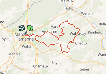
Trail Trail of 32 km to be discovered at Wallonia, Luxembourg, Marche-en-Famenne. This trail is proposed by daniel_2w.
Description
Des chemins parfois techniques vous emmènent vers les villages de Verdenne, Marenne, Menil-Favay, Waharday, Grimbiémont et Champlon-Famenne. Une descente difficile à négocier pour rejoindre Waharday.
Positioning
Country:
Belgium
Region :
Wallonia
Department/Province :
Luxembourg
Municipality :
Marche-en-Famenne
Location:
Marche-en-Famenne
Start:(Dec)
Start:(UTM)
667124 ; 5566738 (31U) N.
Comments