


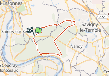
Rougeau et château de la Grange

dmatignon
User


2h58
Difficulty : Easy

FREE GPS app for hiking
 SityTrail
IGN / Geographical institutes
SityTrail Plus
The world is yours!
About
Trail Walking of 12.1 km to be discovered at Ile-de-France, Essonne, Saint-Pierre-du-Perray. This trail is proposed by dmatignon.
Description
Randonnée de découverte de la forêt de Rougeau qui passe par les points les plus caractéristiques : ravin du gouffre, four à chaux, pavillons royal, gardien de la forêt, château de la Grange-Prévôté, allée royale.

Positioning
Comments