


bois d Aix

Christian Demoulib
User
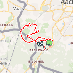

Length
15.2 km

Max alt
354 m

Uphill gradient
328 m
Km-Effort
19.6 km

Min alt
239 m

Downhill gradient
335 m
Boucle
Yes
Creation date :
2019-11-01 12:37:30.152
Updated on :
2019-11-01 19:56:26.652
3h10
Difficulty : Easy

FREE GPS app for hiking
 SityTrail
IGN / Geographical institutes
SityTrail Plus
The world is yours!
About
Trail Walking of 15.2 km to be discovered at North Rhine-Westphalia, Städteregion Aachen, Aachen. This trail is proposed by Christian Demoulib.
Positioning
Country:
Germany
Region :
North Rhine-Westphalia
Department/Province :
Städteregion Aachen
Municipality :
Aachen
Location:
Aachen-Mitte
Start:(Dec)
Start:(UTM)
291987 ; 5625051 (32U) N.
Comments