


Jurassic Tour 2013

gilbinrod
User

Length
62 km

Max alt
3083 m

Uphill gradient
4871 m
Km-Effort
127 km

Min alt
817 m

Downhill gradient
4882 m
Boucle
Yes
Creation date :
2017-07-30 00:00:00.0
Updated on :
2017-07-30 00:00:00.0
30h00
Difficulty : Unknown

FREE GPS app for hiking
 SityTrail
IGN / Geographical institutes
SityTrail Plus
The world is yours!
About
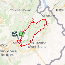
Trail Walking of 62 km to be discovered at Auvergne-Rhône-Alpes, Upper Savoy, Servoz. This trail is proposed by gilbinrod.
Positioning
Country:
France
Region :
Auvergne-Rhône-Alpes
Department/Province :
Upper Savoy
Municipality :
Servoz
Location:
Unknown
Start:(Dec)
Start:(UTM)
327276 ; 5090156 (32T) N.
Comments