2019-11-02 Forêt de Offendorf

Bernardb44
User
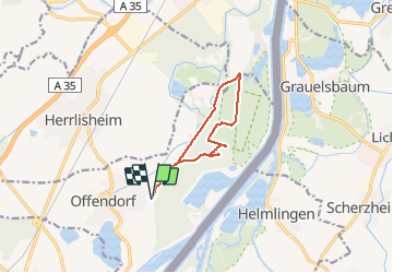

Length
9.2 km

Max alt
133 m

Uphill gradient
60 m
Km-Effort
10.1 km

Min alt
118 m

Downhill gradient
63 m
Boucle
Yes
Creation date :
2019-11-02 13:06:28.889
Updated on :
2019-11-02 15:51:06.748
2h43
Difficulty : Easy

FREE GPS app for hiking
 SityTrail
IGN / Geographical institutes
SityTrail Plus
The world is yours!
About
Trail Walking of 9.2 km to be discovered at Grand Est, Bas-Rhin, Offendorf. This trail is proposed by Bernardb44.
Positioning
Country:
France
Region :
Grand Est
Department/Province :
Bas-Rhin
Municipality :
Offendorf
Location:
Unknown
Start:(Dec)
Start:(UTM)
421145 ; 5396015 (32U) N.
Comments