


Ceinture verte d'Ostende

verpoorten
User
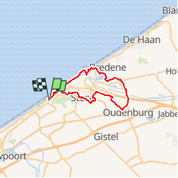

Length
36 km

Max alt
31 m

Uphill gradient
207 m
Km-Effort
39 km

Min alt
-7 m

Downhill gradient
207 m
Boucle
Yes
Creation date :
2019-11-03 11:45:43.819
Updated on :
2019-11-03 11:46:35.244
3h00
Difficulty : Very easy

FREE GPS app for hiking
 SityTrail
IGN / Geographical institutes
SityTrail Plus
The world is yours!
About
Trail Cycle of 36 km to be discovered at Flanders, West Flanders, Ostend. This trail is proposed by verpoorten.
Positioning
Country:
Belgium
Region :
Flanders
Department/Province :
West Flanders
Municipality :
Ostend
Location:
Oostende
Start:(Dec)
Start:(UTM)
489555 ; 5671961 (31U) N.
Comments