Trail Mountain bike Allemagne-en-Provence - boucle Allemagne via esparron,quinson et albiosc - Photo

boucle Allemagne via esparron,quinson et albiosc

© OpenStreetMap contributors
Length
Length
42 km
Max alt
Max alt
593 m
Uphill gradient
Uphill gradient
839 m
Km-Effort
Km-Effort  
53 km
Min alt
Min alt
366 m
Downhill gradient
Downhill gradient
834 m
Boucle
Boucle
Yes
Creation date :
2014-12-10 00:00:00.0
Updated on :
2014-12-10 00:00:00.0

(0 Reviews)

Mountain bike
Mountain bike
4h12
Difficulty : Difficult

Scan this QR Code to open this trail in the SityTrail application

FREE GPS app for hiking

Logo SityTrail SityTrail

IGN / Geographical institutes

Download SityTrail from the App Store Download SityTrail from Google Play

Logo SityTrail SityTrail World

The world is yours!

Download SityTrail from the App Store Download SityTrail from Google Play Download SityTrail on Huawei AppGallery

About

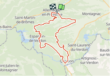
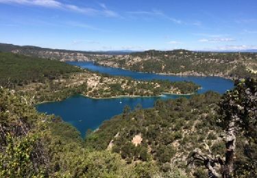
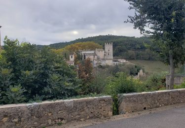
Trail Mountain bike of 42 km to be discovered at Provence-Alpes-Côte d'Azur, Alpes-de-Haute-Provence, Allemagne-en-Provence. This trail is proposed by bernardcornu.

Description

rando très variée donc sympa
pour tous les gouts, sentiers,singles
descente technique et même poussette
(sans déshonneur, bien sûr)

Elevation profile

Positioning

Country:
France
Region :
Provence-Alpes-Côte d'Azur
Department/Province :
Alpes-de-Haute-Provence
Municipality :
Allemagne-en-Provence
Location:
Unknown
Start:(UTM)
260067 ; 4851722 (32T) N.

Trails nearby

Trail Walking Esparron-de-Verdon - 2023-01-10 Esparron - Côte de Vauclare - Photo
Walking
GUIDE
Kargil

Walking

Easy
Esparron-de-Verdon, Provence-Alpes-Côte d'Azur, Alpes-de-Haute-Provence, France
12.4 km | 16.5 km-effort
4h 7min
Yes
Trail Walking Valensole - TOUR DESLAVANDES A VALENSOLE - Photo
Walking
PATRICK8455

Walking

Very easy
(1)
Valensole, Provence-Alpes-Côte d'Azur, Alpes-de-Haute-Provence, France
14.7 km | 17.5 km-effort
4h 26min
Yes
Trail Walking Esparron-de-Verdon - esparron - Photo
Walking
arnaudconde

Walking

Medium
(3)
Esparron-de-Verdon, Provence-Alpes-Côte d'Azur, Alpes-de-Haute-Provence, France
5.4 km | 8 km-effort
Unknown
Yes
Trail Walking Esparron-de-Verdon - 2024-01-16 Esparron - Source des Cades  - Photo
Walking
GUIDE
Kargil

Walking

Easy
Esparron-de-Verdon, Provence-Alpes-Côte d'Azur, Alpes-de-Haute-Provence, France
15 km | 21 km-effort
4h 40min
Yes
Trail Walking Montagnac-Montpezat - Artignosv - Photo
Walking
avdem

Walking

Easy
Montagnac-Montpezat, Provence-Alpes-Côte d'Azur, Alpes-de-Haute-Provence, France
13.1 km | 17.5 km-effort
5h 37min
No
Trail On foot Esparron-de-Verdon - Esparron de Verdon - Photo
On foot
jeromelacoste

On foot

Medium
Esparron-de-Verdon, Provence-Alpes-Côte d'Azur, Alpes-de-Haute-Provence, France
5.5 km | 8.3 km-effort
1h 40min
Yes
Trail Walking Allemagne-en-Provence - Allemagne-en-Provence - Photo
Walking
aubr

Walking

Medium
Allemagne-en-Provence, Provence-Alpes-Côte d'Azur, Alpes-de-Haute-Provence, France
6.6 km | 9.4 km-effort
1h 58min
Yes
Trail Other activity Esparron-de-Verdon - Gorges du Verdon - Partie basse - Photo
Other activity
jfdeligementon

Other activity

Medium
(1)
Esparron-de-Verdon, Provence-Alpes-Côte d'Azur, Alpes-de-Haute-Provence, France
9.2 km | 11.7 km-effort
2h 30min
No
Trail Walking Esparron-de-Verdon - Le lac d'Esparon et le site de la salle à manger - Photo
Walking
boulinevelyne

Walking

Very difficult
Esparron-de-Verdon, Provence-Alpes-Côte d'Azur, Alpes-de-Haute-Provence, France
15.9 km | 23 km-effort
5h 11min
Yes


Close
My subscriptions