
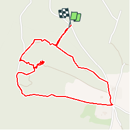
Le Mont Miéry

bob2023
User

Length
2.6 km

Max alt
370 m

Uphill gradient
82 m
Km-Effort
3.7 km

Min alt
324 m

Downhill gradient
88 m
Boucle
Yes
Creation date :
2018-08-26 08:32:34.454
Updated on :
2018-08-26 08:32:34.476
47m
Difficulty : Very easy

FREE GPS app for hiking
 SityTrail
IGN / Geographical institutes
SityTrail Plus
The world is yours!
About
Trail Walking of 2.6 km to be discovered at Auvergne-Rhône-Alpes, Drôme, Upie. This trail is proposed by bob2023.
Description
balade bucolique. Petit chemin dans les bois. Montée très raide sur 100 m pour aller à la Vierge mais vaut le coups. Point de vue à 360° sur toute la vallée. Note 8/10
Photos


Positioning
Country:
France
Region :
Auvergne-Rhône-Alpes
Department/Province :
Drôme
Municipality :
Upie
Location:
Unknown
Start:(Dec)
Start:(UTM)
656720 ; 4962011 (31T) N.
Comments