


cammazes

vertygo
User
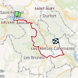

Length
10.1 km

Max alt
638 m

Uphill gradient
334 m
Km-Effort
13.7 km

Min alt
354 m

Downhill gradient
81 m
Boucle
No
Creation date :
2019-11-02 09:00:00.964
Updated on :
2019-11-04 10:11:34.473
3h01
Difficulty : Very easy

FREE GPS app for hiking
 SityTrail
IGN / Geographical institutes
SityTrail Plus
The world is yours!
About
Trail Walking of 10.1 km to be discovered at Occitania, Haute-Garonne, Vaudreuille. This trail is proposed by vertygo.
Positioning
Country:
France
Region :
Occitania
Department/Province :
Haute-Garonne
Municipality :
Vaudreuille
Location:
Unknown
Start:(Dec)
Start:(UTM)
421181 ; 4809443 (31T) N.
Comments