


05-09---13

hm
User
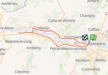

Length
28 km

Max alt
70 m

Uphill gradient
171 m
Km-Effort
30 km

Min alt
35 m

Downhill gradient
172 m
Boucle
Yes
Creation date :
2014-12-10 00:00:00.0
Updated on :
2014-12-10 00:00:00.0
1h53
Difficulty : Very easy

FREE GPS app for hiking
 SityTrail
IGN / Geographical institutes
SityTrail Plus
The world is yours!
About
Trail Mountain bike of 28 km to be discovered at Hauts-de-France, Aisne, Soissons. This trail is proposed by hm.
Description
hm
Positioning
Country:
France
Region :
Hauts-de-France
Department/Province :
Aisne
Municipality :
Soissons
Location:
Unknown
Start:(Dec)
Start:(UTM)
522487 ; 5470053 (31U) N.
Comments