


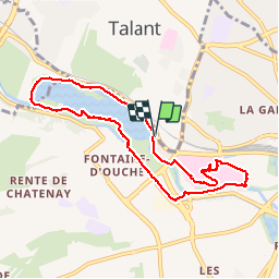
DIJON ; Lac Kir, Puits de Moïse (04-11-2019)

Maurice49
User

Length
8.1 km

Max alt
255 m

Uphill gradient
77 m
Km-Effort
9.1 km

Min alt
235 m

Downhill gradient
76 m
Boucle
Yes
Creation date :
2019-11-04 13:10:41.355
Updated on :
2019-11-05 14:18:12.158
2h20
Difficulty : Very easy

FREE GPS app for hiking
 SityTrail
IGN / Geographical institutes
SityTrail Plus
The world is yours!
About
Trail Walking of 8.1 km to be discovered at Bourgogne-Franche-Comté, Côte-d'Or, Dijon. This trail is proposed by Maurice49.
Photos
 - Photo 1")
 - Photo 2")
 - Photo 3")
 - Photo 4")
 - Photo 5")
 - Photo 6")
 - Photo 7")
 - Photo 8")
 - Photo 9")
 - Photo 10")
 - Photo 11")
 - Photo 12")
 - Photo 13")
 - Photo 14")
 - Photo 15")
 - Photo 16")
 - Photo 17")
 - Photo 18")
 - Photo 19")
 - Photo 20")
 - Photo 21")
 - Photo 22")
 - Photo 23")
 - Photo 24")
 - Photo 25")
 - Photo 26")
 - Photo 27")
 - Photo 28")
 - Photo 29")
 - Photo 30")
 - Photo 31")
 - Photo 32")
 - Photo 33")
 - Photo 34")
 - Photo 35")
 - Photo 36")
 - Photo 37")
 - Photo 38")
 - Photo 39")
39 photos in total. Please click on a photo to see them all in the gallery.
Positioning
Country:
France
Region :
Bourgogne-Franche-Comté
Department/Province :
Côte-d'Or
Municipality :
Dijon
Location:
Unknown
Start:(Dec)
Start:(UTM)
651730 ; 5243172 (31T) N.
Comments