


Marcilly en Villette 2019

Rembliere
User

Length
12.7 km

Max alt
132 m

Uphill gradient
77 m
Km-Effort
13.7 km

Min alt
109 m

Downhill gradient
77 m
Boucle
Yes
Creation date :
2019-11-05 14:24:29.219
Updated on :
2019-11-05 14:26:30.399
3h03
Difficulty : Difficult

FREE GPS app for hiking
 SityTrail
IGN / Geographical institutes
SityTrail Plus
The world is yours!
About
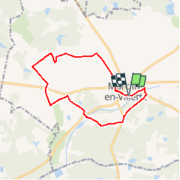
Trail Walking of 12.7 km to be discovered at Centre-Loire Valley, Loiret, Marcilly-en-Villette. This trail is proposed by Rembliere.
Positioning
Country:
France
Region :
Centre-Loire Valley
Department/Province :
Loiret
Municipality :
Marcilly-en-Villette
Location:
Unknown
Start:(Dec)
Start:(UTM)
426766 ; 5290308 (31T) N.
Comments