


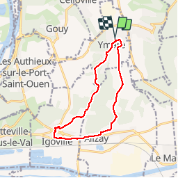
20191029 Ymare

Childebert
User

Length
11.2 km

Max alt
143 m

Uphill gradient
178 m
Km-Effort
13.6 km

Min alt
7 m

Downhill gradient
178 m
Boucle
Yes
Creation date :
2019-10-29 12:42:12.804
Updated on :
2019-11-05 18:13:45.466
2h58
Difficulty : Easy

FREE GPS app for hiking
 SityTrail
IGN / Geographical institutes
SityTrail Plus
The world is yours!
About
Trail Walking of 11.2 km to be discovered at Normandy, Seine-Maritime, Ymare. This trail is proposed by Childebert.
Positioning
Country:
France
Region :
Normandy
Department/Province :
Seine-Maritime
Municipality :
Ymare
Location:
Unknown
Start:(Dec)
Start:(UTM)
367585 ; 5468073 (31U) N.
Comments