


st restitut

gout.marc
User
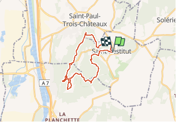

Length
14.4 km

Max alt
284 m

Uphill gradient
361 m
Km-Effort
19.2 km

Min alt
150 m

Downhill gradient
361 m
Boucle
Yes
Creation date :
2019-05-06 10:14:17.069
Updated on :
2019-11-06 15:26:17.976
4h05
Difficulty : Medium

FREE GPS app for hiking
 SityTrail
IGN / Geographical institutes
SityTrail Plus
The world is yours!
About
Trail Walking of 14.4 km to be discovered at Auvergne-Rhône-Alpes, Drôme, Saint-Restitut. This trail is proposed by gout.marc.
Description
trés belle rando,chapelles,carriéres,chateau et site du Barry
Positioning
Country:
France
Region :
Auvergne-Rhône-Alpes
Department/Province :
Drôme
Municipality :
Saint-Restitut
Location:
Unknown
Start:(Dec)
Start:(UTM)
642773 ; 4910206 (31T) N.
Comments