


la loube

tosan
User
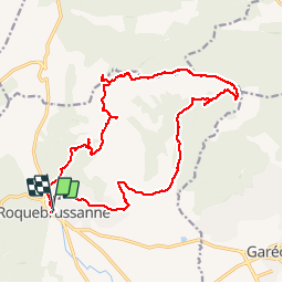

Length
22 km

Max alt
818 m

Uphill gradient
811 m
Km-Effort
32 km

Min alt
361 m

Downhill gradient
808 m
Boucle
Yes
Creation date :
2019-11-06 08:14:21.113
Updated on :
2019-11-06 18:09:28.332
7h48
Difficulty : Very easy

FREE GPS app for hiking
 SityTrail
IGN / Geographical institutes
SityTrail Plus
The world is yours!
About
Trail Walking of 22 km to be discovered at Provence-Alpes-Côte d'Azur, Var, La Roquebrussanne. This trail is proposed by tosan.
Positioning
Country:
France
Region :
Provence-Alpes-Côte d'Azur
Department/Province :
Var
Municipality :
La Roquebrussanne
Location:
Unknown
Start:(Dec)
Start:(UTM)
741266 ; 4802662 (31T) N.
Comments