


67 Boucle Schneeberg

LUTZMarc
User
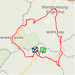

Length
20 km

Max alt
929 m

Uphill gradient
884 m
Km-Effort
32 km

Min alt
423 m

Downhill gradient
879 m
Boucle
Yes
Creation date :
2019-11-07 08:21:59.346
Updated on :
2019-11-07 17:55:26.315
5h06
Difficulty : Medium

FREE GPS app for hiking
 SityTrail
IGN / Geographical institutes
SityTrail Plus
The world is yours!
About
Trail Walking of 20 km to be discovered at Grand Est, Bas-Rhin, Oberhaslach. This trail is proposed by LUTZMarc.
Description
La rando est principalement sur des sentier en forêt. Très agréable aà marcher. Ça monte bien par moment. Possibilité de manger à l'auberge du château à Wangenbourg km 12.
Positioning
Country:
France
Region :
Grand Est
Department/Province :
Bas-Rhin
Municipality :
Oberhaslach
Location:
Unknown
Start:(Dec)
Start:(UTM)
373846 ; 5382873 (32U) N.
Comments