


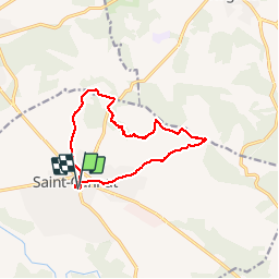
St Cannat - fontaine Doudonne

mhetpierre
User

Length
12.2 km

Max alt
341 m

Uphill gradient
185 m
Km-Effort
14.7 km

Min alt
203 m

Downhill gradient
187 m
Boucle
Yes
Creation date :
2019-11-08 09:11:02.228
Updated on :
2019-11-11 09:56:25.46
3h33
Difficulty : Very easy

FREE GPS app for hiking
 SityTrail
IGN / Geographical institutes
SityTrail Plus
The world is yours!
About
Trail Walking of 12.2 km to be discovered at Provence-Alpes-Côte d'Azur, Bouches-du-Rhône, Saint-Cannat. This trail is proposed by mhetpierre.
Positioning
Country:
France
Region :
Provence-Alpes-Côte d'Azur
Department/Province :
Bouches-du-Rhône
Municipality :
Saint-Cannat
Location:
Unknown
Start:(Dec)
Start:(UTM)
685426 ; 4832154 (31T) N.
Comments