


le pont Julien/ Roussillon.

fernandezyvan
User
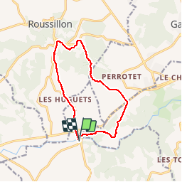

Length
12.6 km

Max alt
306 m

Uphill gradient
223 m
Km-Effort
15.6 km

Min alt
167 m

Downhill gradient
223 m
Boucle
Yes
Creation date :
2019-11-08 08:12:54.524
Updated on :
2019-11-08 13:54:54.994
4h23
Difficulty : Easy

FREE GPS app for hiking
 SityTrail
IGN / Geographical institutes
SityTrail Plus
The world is yours!
About
Trail Walking of 12.6 km to be discovered at Provence-Alpes-Côte d'Azur, Vaucluse, Bonnieux. This trail is proposed by fernandezyvan.
Positioning
Country:
France
Region :
Provence-Alpes-Côte d'Azur
Department/Province :
Vaucluse
Municipality :
Bonnieux
Location:
Unknown
Start:(Dec)
Start:(UTM)
685369 ; 4859081 (31T) N.
Comments