


Mt St Père Rando Santé

VANDERPUTTENMi
User GUIDE
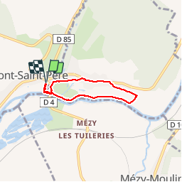

Length
4.5 km

Max alt
82 m

Uphill gradient
37 m
Km-Effort
5 km

Min alt
58 m

Downhill gradient
38 m
Boucle
Yes
Creation date :
2019-11-08 12:53:53.78
Updated on :
2019-11-08 14:49:23.542
1h54
Difficulty : Very easy

FREE GPS app for hiking
 SityTrail
IGN / Geographical institutes
SityTrail Plus
The world is yours!
About
Trail Walking of 4.5 km to be discovered at Hauts-de-France, Aisne, Mont-Saint-Père. This trail is proposed by VANDERPUTTENMi.
Positioning
Country:
France
Region :
Hauts-de-France
Department/Province :
Aisne
Municipality :
Mont-Saint-Père
Location:
Unknown
Start:(Dec)
Start:(UTM)
536144 ; 5435857 (31U) N.
Comments