


CLAMENSANNE . Bergerie de Bane , Parustre , Col de la Baisse , aqueduc de o s Sanieres

RobinMicheline
User GUIDE
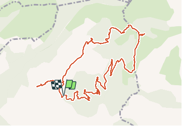

Length
14 km

Max alt
1598 m

Uphill gradient
843 m
Km-Effort
25 km

Min alt
796 m

Downhill gradient
849 m
Boucle
Yes
Creation date :
2019-11-09 07:55:03.76
Updated on :
2020-07-16 14:30:07.524
7h04
Difficulty : Difficult

FREE GPS app for hiking
 SityTrail
IGN / Geographical institutes
SityTrail Plus
The world is yours!
About
Trail Walking of 14 km to be discovered at Provence-Alpes-Côte d'Azur, Alpes-de-Haute-Provence, Clamensane. This trail is proposed by RobinMicheline.
Description
super , vue à 360 degrés, quelques sentiers un peu raide , bel Aqueduc o l s
Positioning
Country:
France
Region :
Provence-Alpes-Côte d'Azur
Department/Province :
Alpes-de-Haute-Provence
Municipality :
Clamensane
Location:
Unknown
Start:(Dec)
Start:(UTM)
267362 ; 4913277 (32T) N.
Comments