


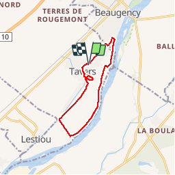
tavers Bord de Loire et les Eaux Bleues
CLÉRY Rando
Si tu veux marcher vite, marche seul; si tu veux marcher loin, marche avec les autres.

Length
10.3 km

Max alt
107 m

Uphill gradient
69 m
Km-Effort
11.2 km

Min alt
76 m

Downhill gradient
70 m
Boucle
Yes
Creation date :
2019-11-09 13:09:31.263
Updated on :
2019-11-09 19:05:56.426
2h47
Difficulty : Very easy

FREE GPS app for hiking
 SityTrail
IGN / Geographical institutes
SityTrail Plus
The world is yours!
About
Trail Walking of 10.3 km to be discovered at Centre-Loire Valley, Loiret, Tavers. This trail is proposed by CLÉRY Rando.
Positioning
Country:
France
Region :
Centre-Loire Valley
Department/Province :
Loiret
Municipality :
Tavers
Location:
Unknown
Start:(Dec)
Start:(UTM)
396345 ; 5290562 (31T) N.
Comments