


Col de Montmirat

denis48230
User
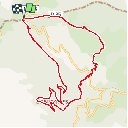

Length
12.3 km

Max alt
1078 m

Uphill gradient
456 m
Km-Effort
18.4 km

Min alt
678 m

Downhill gradient
461 m
Boucle
Yes
Creation date :
2019-11-09 11:54:29.708
Updated on :
2019-11-09 16:46:35.759
4h07
Difficulty : Very easy

FREE GPS app for hiking
 SityTrail
IGN / Geographical institutes
SityTrail Plus
The world is yours!
About
Trail Walking of 12.3 km to be discovered at Occitania, Lozère, Saint-Étienne-du-Valdonnez. This trail is proposed by denis48230.
Positioning
Country:
France
Region :
Occitania
Department/Province :
Lozère
Municipality :
Saint-Étienne-du-Valdonnez
Location:
Unknown
Start:(Dec)
Start:(UTM)
543332 ; 4918538 (31T) N.
Comments