


cap lardier et taillat par collebasse

clintest
User
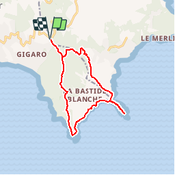

Length
13.9 km

Max alt
177 m

Uphill gradient
435 m
Km-Effort
19.7 km

Min alt
0 m

Downhill gradient
434 m
Boucle
Yes
Creation date :
2019-11-09 21:04:07.693
Updated on :
2019-11-09 21:05:16.747
--
Difficulty : Medium

FREE GPS app for hiking
 SityTrail
IGN / Geographical institutes
SityTrail Plus
The world is yours!
About
Trail On foot of 13.9 km to be discovered at Provence-Alpes-Côte d'Azur, Var, Ramatuelle. This trail is proposed by clintest.
Positioning
Country:
France
Region :
Provence-Alpes-Côte d'Azur
Department/Province :
Var
Municipality :
Ramatuelle
Location:
Unknown
Start:(Dec)
Start:(UTM)
305715 ; 4785288 (32T) N.
Comments