


SityTrail - 12.09.2018 - ST MEDARD ouest et est

chasle
User
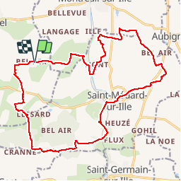

Length
21 km

Max alt
116 m

Uphill gradient
252 m
Km-Effort
25 km

Min alt
49 m

Downhill gradient
250 m
Boucle
Yes
Creation date :
2019-11-10 10:39:39.566
Updated on :
2019-11-10 10:52:32.654
5h26
Difficulty : Easy

FREE GPS app for hiking
 SityTrail
IGN / Geographical institutes
SityTrail Plus
The world is yours!
About
Trail Walking of 21 km to be discovered at Brittany, Ille-et-Vilaine, Guipel. This trail is proposed by chasle.
Positioning
Country:
France
Region :
Brittany
Department/Province :
Ille-et-Vilaine
Municipality :
Guipel
Location:
Unknown
Start:(Dec)
Start:(UTM)
596445 ; 5348868 (30U) N.
Comments