


Mes 4 Lacs

neurone57
User
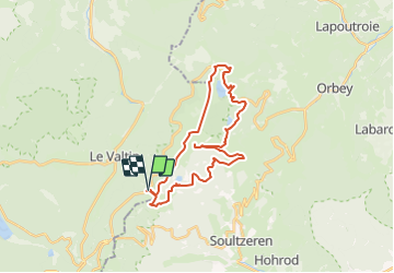

Length
27 km

Max alt
1304 m

Uphill gradient
896 m
Km-Effort
39 km

Min alt
909 m

Downhill gradient
882 m
Boucle
Yes
Creation date :
2014-12-10 00:00:00.0
Updated on :
2014-12-10 00:00:00.0
3h20
Difficulty : Unknown

FREE GPS app for hiking
 SityTrail
IGN / Geographical institutes
SityTrail Plus
The world is yours!
About
Trail Other activity of 27 km to be discovered at Grand Est, Vosges, Le Valtin. This trail is proposed by neurone57.
Description
Longue rando facile
Positioning
Country:
France
Region :
Grand Est
Department/Province :
Vosges
Municipality :
Le Valtin
Location:
Unknown
Start:(Dec)
Start:(UTM)
354445 ; 5327495 (32U) N.
Comments