


st.marc.alain.francoise

NADINE52
User
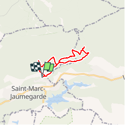

Length
10.5 km

Max alt
509 m

Uphill gradient
163 m
Km-Effort
12.6 km

Min alt
440 m

Downhill gradient
163 m
Boucle
Yes
Creation date :
2019-11-11 09:03:30.942
Updated on :
2019-11-11 13:35:58.503
3h26
Difficulty : Very easy

FREE GPS app for hiking
 SityTrail
IGN / Geographical institutes
SityTrail Plus
The world is yours!
About
Trail Walking of 10.5 km to be discovered at Provence-Alpes-Côte d'Azur, Bouches-du-Rhône, Saint-Marc-Jaumegarde. This trail is proposed by NADINE52.
Photos

Positioning
Country:
France
Region :
Provence-Alpes-Côte d'Azur
Department/Province :
Bouches-du-Rhône
Municipality :
Saint-Marc-Jaumegarde
Location:
Unknown
Start:(Dec)
Start:(UTM)
704581 ; 4825526 (31T) N.
Comments