


Châtillon d'Azergues

daniellebou
User
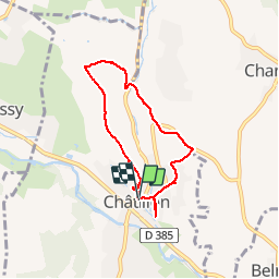

Length
6 km

Max alt
311 m

Uphill gradient
169 m
Km-Effort
8.2 km

Min alt
212 m

Downhill gradient
167 m
Boucle
Yes
Creation date :
2019-11-11 14:44:47.126
Updated on :
2019-11-11 16:41:56.928
1h55
Difficulty : Very easy

FREE GPS app for hiking
 SityTrail
IGN / Geographical institutes
SityTrail Plus
The world is yours!
About
Trail Walking of 6 km to be discovered at Auvergne-Rhône-Alpes, Rhône, Châtillon. This trail is proposed by daniellebou.
Positioning
Country:
France
Region :
Auvergne-Rhône-Alpes
Department/Province :
Rhône
Municipality :
Châtillon
Location:
Unknown
Start:(Dec)
Start:(UTM)
627693 ; 5081715 (31T) N.
Comments