


GQg-kZIfY2Y

Renefrt
User
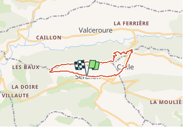

Length
11.7 km

Max alt
1625 m

Uphill gradient
553 m
Km-Effort
19.1 km

Min alt
1127 m

Downhill gradient
557 m
Boucle
Yes
Creation date :
2019-11-11 19:46:08.0
Updated on :
2020-03-05 19:52:40.125
--
Difficulty : Medium

FREE GPS app for hiking
 SityTrail
IGN / Geographical institutes
SityTrail Plus
The world is yours!
About
Trail On foot of 11.7 km to be discovered at Provence-Alpes-Côte d'Azur, Maritime Alps, Séranon. This trail is proposed by Renefrt.
Description
Pas encore faite
Positioning
Country:
France
Region :
Provence-Alpes-Côte d'Azur
Department/Province :
Maritime Alps
Municipality :
Séranon
Location:
Unknown
Start:(Dec)
Start:(UTM)
315198 ; 4849370 (32T) N.
Comments