


111119Sion le Mines / La Dominelais

chasle
User
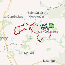

Length
25 km

Max alt
83 m

Uphill gradient
253 m
Km-Effort
28 km

Min alt
20 m

Downhill gradient
255 m
Boucle
Yes
Creation date :
2019-11-11 20:08:00.226
Updated on :
2019-11-19 22:31:06.489
5h57
Difficulty : Easy

FREE GPS app for hiking
 SityTrail
IGN / Geographical institutes
SityTrail Plus
The world is yours!
About
Trail Walking of 25 km to be discovered at Pays de la Loire, Loire-Atlantique, Sion-les-Mines. This trail is proposed by chasle.
Positioning
Country:
France
Region :
Pays de la Loire
Department/Province :
Loire-Atlantique
Municipality :
Sion-les-Mines
Location:
Unknown
Start:(Dec)
Start:(UTM)
605562 ; 5287823 (30T) N.
Comments