


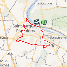
Ponthierry Pringy 12-11-2019

robinier
User

Length
12.4 km

Max alt
82 m

Uphill gradient
128 m
Km-Effort
14.1 km

Min alt
38 m

Downhill gradient
129 m
Boucle
Yes
Creation date :
2019-11-12 08:04:16.0
Updated on :
2019-11-12 11:28:42.994
3h04
Difficulty : Unknown

FREE GPS app for hiking
 SityTrail
IGN / Geographical institutes
SityTrail Plus
The world is yours!
About
Trail Walking of 12.4 km to be discovered at Ile-de-France, Seine-et-Marne, Saint-Fargeau-Ponthierry. This trail is proposed by robinier.
Photos


Positioning
Country:
France
Region :
Ile-de-France
Department/Province :
Seine-et-Marne
Municipality :
Saint-Fargeau-Ponthierry
Location:
Unknown
Start:(Dec)
Start:(UTM)
466532 ; 5376010 (31U) N.
Comments