


les salces

ARVIEU
User

Length
21 km

Max alt
767 m

Uphill gradient
743 m
Km-Effort
31 km

Min alt
306 m

Downhill gradient
745 m
Boucle
Yes
Creation date :
2019-11-12 08:06:09.614
Updated on :
2019-11-12 15:07:54.85
5h43
Difficulty : Very easy

FREE GPS app for hiking
 SityTrail
IGN / Geographical institutes
SityTrail Plus
The world is yours!
About
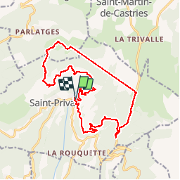
Trail Walking of 21 km to be discovered at Occitania, Hérault, Saint-Privat. This trail is proposed by ARVIEU.
Description
montée sur la Larzac
Positioning
Country:
France
Region :
Occitania
Department/Province :
Hérault
Municipality :
Saint-Privat
Location:
Unknown
Start:(Dec)
Start:(UTM)
535160 ; 4844765 (31T) N.
Comments