Trail Walking Consolation-Maisonnettes - N.-D. de Consolation - Roche du Prêtre - Photo

N.-D. de Consolation - Roche du Prêtre

 albert39
albert39

User

© OpenStreetMap contributors
Length
Length
16.3 km
Max alt
Max alt
875 m
Uphill gradient
Uphill gradient
488 m
Km-Effort
Km-Effort  
23 km
Min alt
Min alt
500 m
Downhill gradient
Downhill gradient
497 m
Boucle
Boucle
Yes
Creation date :
2014-12-10 00:00:00.0
Updated on :
2014-12-10 00:00:00.0

(0 Reviews)

Walking
Walking
4h39
Difficulty : Difficult

Scan this QR Code to open this trail in the SityTrail application

FREE GPS app for hiking

Logo SityTrail SityTrail

IGN / Geographical institutes

Download SityTrail from the App Store Download SityTrail from Google Play

Logo SityTrail SityTrail Plus

The world is yours!

Download SityTrail from the App Store Download SityTrail from Google Play Download SityTrail on Huawei AppGallery

About

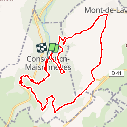
Trail Walking of 16.3 km to be discovered at Bourgogne-Franche-Comté, Doubs, Consolation-Maisonnettes. This trail is proposed by albert39.

Description

Départ parking séminaire, par le parc, Val Noir, Belvédère Ste-Catherine, Roche Ste-Catherine, Crête et source du Dessoubre, la Scie Dessus, montée au Belvédère et Roche du Prêtre, la grange la Picotte, les Champs Raccordons, Mont de Laval, Belvédère de la Côte de la Consolation et retour parking.

Elevation profile

Positioning

Country:
France
Region :
Bourgogne-Franche-Comté
Department/Province :
Doubs
Municipality :
Consolation-Maisonnettes
Location:
Unknown
Start:(UTM)
318478 ; 5225552 (32T) N.


Close
My subscriptions