


Flamands roses

jpipacific
User
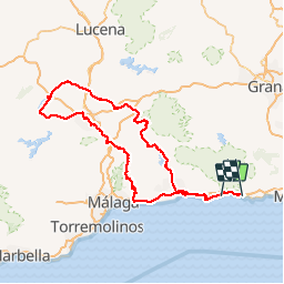

Length
296 km

Max alt
1045 m

Uphill gradient
5364 m
Km-Effort
368 km

Min alt
0 m

Downhill gradient
5237 m
Boucle
No
Creation date :
2019-11-13 08:22:05.323
Updated on :
2019-11-13 09:08:21.342
5h00
Difficulty : Very easy

FREE GPS app for hiking
 SityTrail
IGN / Geographical institutes
SityTrail Plus
The world is yours!
About
Trail Moto cross of 296 km to be discovered at Andalusia, Malaga, Nerja. This trail is proposed by jpipacific.
Description
Faite avec HONDA Africa Twin CRF 1000
Très belle route et bon restaurant à Fuente de la Piedra (Bar TEJADA sur la place de la Constitucion)
Vu les Flamnds roses prés du centre des visiteurs.
Photos


Positioning
Country:
Spain
Region :
Andalusia
Department/Province :
Malaga
Municipality :
Nerja
Location:
Unknown
Start:(Dec)
Start:(UTM)
420900 ; 4067264 (30S) N.
Comments