


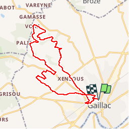
Les hauts de Gaillac

pidjam
User


--
Difficulty : Medium

FREE GPS app for hiking
 SityTrail
IGN / Geographical institutes
SityTrail Plus
The world is yours!
About
Trail On foot of 18.9 km to be discovered at Occitania, Tarn, Gaillac. This trail is proposed by pidjam.
Description
Partez à la découverte des coteaux du vignoble de Gaillac.Partez à la rencontre de l'histoire du vin de Gaillac à travers cette randonnée de 18 km. Il faut savoir que l'existence de la vigne dans le pays est bien antérieure à la naissance de Gaillac (972), apportée par les romains, un siècle environ avant J.-C., dans une conquête viti-vinicole de l’Aquitaine dont le Gaillacois constitue les premières marches orientales…
Positioning
Comments