


RS-Eperonnière

raymondfn
User
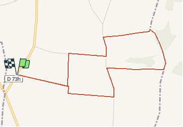

Length
5.7 km

Max alt
398 m

Uphill gradient
51 m
Km-Effort
6.3 km

Min alt
353 m

Downhill gradient
51 m
Boucle
Yes
Creation date :
2019-11-13 15:38:19.436
Updated on :
2020-01-12 12:22:59.044
1h02
Difficulty : Easy

FREE GPS app for hiking
 SityTrail
IGN / Geographical institutes
SityTrail Plus
The world is yours!
About
Trail Walking of 5.7 km to be discovered at Auvergne-Rhône-Alpes, Isère, Gillonnay. This trail is proposed by raymondfn.
Positioning
Country:
France
Region :
Auvergne-Rhône-Alpes
Department/Province :
Isère
Municipality :
Gillonnay
Location:
Unknown
Start:(Dec)
Start:(UTM)
679268 ; 5027103 (31T) N.
Comments