


ponteves

tosan
User
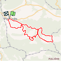

Length
20 km

Max alt
807 m

Uphill gradient
931 m
Km-Effort
32 km

Min alt
364 m

Downhill gradient
929 m
Boucle
Yes
Creation date :
2019-11-13 07:57:22.176
Updated on :
2019-11-13 15:47:19.395
7h32
Difficulty : Very easy

FREE GPS app for hiking
 SityTrail
IGN / Geographical institutes
SityTrail Plus
The world is yours!
About
Trail Walking of 20 km to be discovered at Provence-Alpes-Côte d'Azur, Var, Pontevès. This trail is proposed by tosan.
Positioning
Country:
France
Region :
Provence-Alpes-Côte d'Azur
Department/Province :
Var
Municipality :
Pontevès
Location:
Unknown
Start:(Dec)
Start:(UTM)
260090 ; 4826532 (32T) N.
Comments