dolmen les issambres

clintest
User
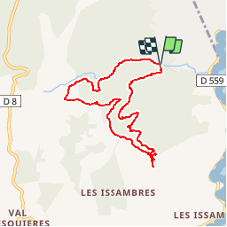

Length
8.8 km

Max alt
237 m

Uphill gradient
311 m
Km-Effort
13 km

Min alt
16 m

Downhill gradient
302 m
Boucle
Yes
Creation date :
2019-11-13 20:31:24.255
Updated on :
2019-11-13 20:32:14.148
--
Difficulty : Easy

FREE GPS app for hiking
 SityTrail
IGN / Geographical institutes
SityTrail Plus
The world is yours!
About
Trail On foot of 8.8 km to be discovered at Provence-Alpes-Côte d'Azur, Var, Roquebrune-sur-Argens. This trail is proposed by clintest.
Positioning
Country:
France
Region :
Provence-Alpes-Côte d'Azur
Department/Province :
Var
Municipality :
Roquebrune-sur-Argens
Location:
Unknown
Start:(Dec)
Start:(UTM)
313869 ; 4804258 (32T) N.
Comments